

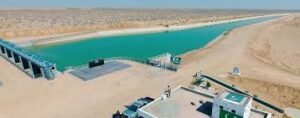
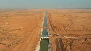
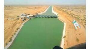
The Kachhi Canal Project is one of Pakistan’s most ambitious irrigation initiatives, designed to transform arid regions of Balochistan into productive agricultural land. By channeling water from the Indus River system, this project aims to uplift local communities, strengthen food security, and drive long-term economic growth.
Beyond its scale, what makes this project notable is its integration of geotechnical monitoring systems to ensure safe and efficient operation.
Project Overview
Initiated in 2002, the Kachhi Canal Project was developed to divert water from the Taunsa Barrage to various parts of Balochistan. The project was planned in three phases, targeting large-scale irrigation and regional development.
Key Highlights:
- Designed to irrigate 720,000 acres of land
- Phase I completed in 2017
- Initial irrigation coverage: 72,000 acres in Dera Bugti
- Targets districts:
- Dera Bugti
- Naseerabad
- Sibi
- Jhal Magsi
The project holds the potential to significantly improve agricultural productivity in one of Pakistan’s driest regions.
Objectives of the Project
The Kachhi Canal Project was launched with several strategic goals:
✔ Expand irrigation infrastructure in Balochistan
✔ Improve socio-economic conditions of rural communities
✔ Reduce dependency on rainfall
✔ Boost agricultural output and employment
Challenges Faced
Despite its promising vision, the project encountered multiple challenges:
- Delays in construction timelines
- Budget overruns
- Implementation and management issues
- Technical and logistical hurdles
These challenges slowed progress but did not diminish the project’s long-term importance.
Monitoring System Implementation
To ensure operational safety and water management efficiency, the project incorporates geotechnical monitoring techniques.
Monitoring Instruments Used
The primary monitoring equipment includes:
- Standpipe Piezometers – used to measure groundwater pressure and seepage conditions
- Water Level Indicators – monitor canal water levels accurately
How the Monitoring System Works
The monitoring system plays a critical role in maintaining canal stability:
- Standpipe piezometers track underground water pressure
- Engineers analyze seepage behavior and soil conditions
- Water level indicators monitor flow consistency
- Data helps prevent structural damage and water loss
This system ensures early detection of potential risks such as:
- Seepage issues
- Soil instability
- Water leakage
- Structural weaknesses
Technologies & Products Used
The project uses reliable and field-tested instrumentation:
- Standpipe Piezometers
- Water Level Indicators
Although simpler compared to dam projects, these tools are essential for canal safety and efficiency.
Key Benefits of the Project
1. Agricultural Transformation
The project brings irrigation to previously barren land, enabling farming at scale.
2. Economic Development
Increased agricultural output creates jobs and improves livelihoods.
3. Water Resource Optimization
Efficient water distribution reduces wastage and improves usage.
4. Infrastructure Growth
The canal network supports long-term regional development.
Project Stakeholders
- Client: WAPDA
- Consultant: NESPAK
- Specialist Contractor: GSI (Geotechnical & Structural Instrumentation)
These stakeholders played a key role in delivering both infrastructure and monitoring solutions.
Conclusion
The Kachhi Canal Project represents a bold step toward transforming Balochistan’s agricultural landscape. While challenges have slowed its progress, its long-term impact remains undeniable.
With the integration of monitoring systems and modern engineering practices, the project is set to enhance water management, improve livelihoods, and contribute to Pakistan’s food security.
FAQs
What is the purpose of the Kachhi Canal Project?
It aims to bring irrigation water to Balochistan and improve agricultural productivity.
Which areas benefit from this project?
Dera Bugti, Naseerabad, Sibi, and Jhal Magsi districts.
What monitoring instruments are used?
Standpipe piezometers and water level indicators.
Why is the project important?
It supports economic growth, agriculture, and water management in a dry region.